Pictures
| # |
ID


|
Uploaded by
|
Uploaded on

|
Picture
|
Description
|
Related item(s)
|


|
| 4526 |
7667 |
 bali |
2018-05-26 21:49:25 |
 |
By United States Geological Survey (USGS) - USGS via TopoQuesthttp://www.topoquest.com/map.php?lat=40.33791&lon=-97.43150&datum=nad83&zoom=4&map=sat1m&coord=d&mode=pan&size=l, Public Domain, https://commons.wikimedia.org/w/index.php?curid=19577573 |
Airport Bruning Army Air Field (_01884) |
|
| 4527 |
7666 |
bali |
2018-05-26 21:49:12 |
 |
By United States Geological Survey (USGS) - USGS The National Map, via MSR Maps (formerly TerraServer-USA):Image: http://msrmaps.com/GetImageArea.ashx?t=1&s=11&lat=31.6754&lon=-99.9748&w=554&h=829Interactive map: http://msrmaps.com/map.aspx?t=1&s=11 |
Airport Bruce Field (_01880) |
|
| 4528 |
7665 |
bali |
2018-05-26 21:48:59 |
 |
By NASA World Wind - NASA, Public Domain, https://commons.wikimedia.org/w/index.php?curid=3165159 |
Airport Bristol Field Airport (_01846) |
|
| 4529 |
7664 |
bali |
2018-05-26 21:48:51 |
 |
By steve bailey, CC BY-SA 2.0, https://commons.wikimedia.org/w/index.php?curid=5554842 |
Airport Bristol (Whitchurch) Airport (_01842) |
|
| 4530 |
7663 |
bali |
2018-05-26 21:48:43 |
 |
By United States Department of Agriculture (USDA), Farm Services Agency - National Agriculture Imagery Program (NAIP) Orthoimagery for Zone 16 Alabama State Quarter Quadrangle BREWTON SOUTH, SE and I.D. # n_3108764_se_16_1_20060630.tif, Public Domai |
Airport Brewton Municipal Airport (_01831) |
|
| 4531 |
7662 |
bali |
2018-05-26 21:48:28 |
 |
By KTrimble at English Wikipedia, CC BY-SA 3.0, https://commons.wikimedia.org/w/index.php?curid=61576723 |
Airport Branson West Airport (_01814) |
|
| 4532 |
7661 |
bali |
2018-05-26 21:48:20 |
 |
By Stefan Kühn - Own work, CC BY-SA 3.0, https://commons.wikimedia.org/w/index.php?curid=44099 |
Airport Brand-Briesen Airfield (_01806) |
|
| 4533 |
7660 |
bali |
2018-05-26 21:48:11 |
 |
By Freeman - http://www.airfields-freeman.com, Public Domain, https://commons.wikimedia.org/w/index.php?curid=29524065 |
Airport Braintree Airport (_01803) |
|
| 4534 |
7659 |
bali |
2018-05-26 21:48:03 |
 |
By Stuart Meek, CC BY-SA 2.0, https://commons.wikimedia.org/w/index.php?curid=9215881 |
Airport Boulmer Airfield (_01765) |
|
| 4535 |
7658 |
bali |
2018-05-26 21:47:54 |
 |
By Civil Air Patrol - Arkansas Department of Aeronautics, Public Domain, https://commons.wikimedia.org/w/index.php?curid=31083259 |
Airport Booneville Municipal Airport (_01722) |
|
| 4536 |
7657 |
bali |
2018-05-26 21:47:45 |
 |
By United States Geological Survey (USGS) - USGS The National Map, via MSR Maps (formerly TerraServer-USA)http://msrmaps.com/map.aspx?t=1&s=12&lon=-90.481111&lat=43.975833&w=600&h=400, Public Domain, https://commons.wikimedia.org/w/index.php?curid=9 |
Airport Bloyer Field (_01638) |
|
| 4537 |
7656 |
bali |
2018-05-26 21:47:32 |
 |
By United States Department of Agriculture (USDA), Farm Services Agency - National Agriculture Imagery Program (NAIP) Orthoimagery for Zone 16 Alabama State Quarter Quadrangle OZARK, NE and I.D. # n_3108535_ne_16_1_20060630.tif, Public Domain, https |
Airport Blackwell Field (_01612) |
|
| 4538 |
7655 |
bali |
2018-05-26 21:47:19 |
 |
By Brocken Inaglory - Own work, CC BY-SA 3.0, https://commons.wikimedia.org/w/index.php?curid=7837591 |
Airport Black Rock City Airport (_01605) |
|
| 4539 |
7654 |
bali |
2018-05-26 21:47:11 |
 |
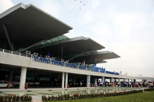
By http://www.canthoairport.vn - http://www.canthoairport.vn, Copyrighted free use, https://commons.wikimedia.org/w/index.php?curid=12531873 |
Airport Binh Thuy Air Base (_01567) |
|
| 4540 |
7653 |
bali |
2018-05-26 21:47:01 |
 |
By Kayhan ERTUGRUL - https://www.panoramio.com/photo/113621623, CC BY-SA 3.0, https://commons.wikimedia.org/w/index.php?curid=50798797 |
Airport Bingöl Çeltiksuyu Airport (_01566) |
|
| 4541 |
7652 |
bali |
2018-05-26 21:46:52 |
 |
By Civil Air Patrol - Arkansas Department of Aeronautics, Public Domain, https://commons.wikimedia.org/w/index.php?curid=50948375 |
Airport Billy Free Municipal Airport (_01561) |
|
| 4542 |
7651 |
bali |
2018-05-26 21:46:43 |
 |
By Vijay.indora - Own work, CC BY-SA 3.0, https://commons.wikimedia.org/w/index.php?curid=15904744 |
Airport Bihta Air Force Station (_01549) |
|
| 4543 |
7650 |
bali |
2018-05-26 21:46:34 |
 |
By Ted Quackenbush - http://www.airliners.net/photo/Air-Rajneesh/Convair-240-0/0069833/L/, GFDL 1.2, https://commons.wikimedia.org/w/index.php?curid=16942411 |
Airport Big Muddy Ranch Airport (_01544) |
|
| 4544 |
7649 |
bali |
2018-05-26 21:46:23 |
 |
By Payette National Forest U.S. Forest Service - https://inciweb.nwcg.gov/incident/photographs/5500/, Public Domain, https://commons.wikimedia.org/w/index.php?curid=62311597 |
Airport Big Creek Airport (Idaho) (_01540) |
|
| 4545 |
7648 |
bali |
2018-05-26 21:46:12 |
 |
By United States Department of Agriculture (USDA), Farm Services Agency - National Agriculture Imagery Program (NAIP) Orthoimagery for Zone 16 Alabama State Quarter Quadrangle CENTREVILLE EAST, SW and I.D. # n_3208708_sw_16_1_20060629.tif, Public Do |
Airport Bibb County Airport (_01529) |
|
| 4546 |
7647 |
bali |
2018-05-26 21:45:59 |
 |
By Federal Aviation Administration, Alaska Region - Image: http://www.alaska.faa.gov/fai/images/YKDELTA/BET-c.jpgWeb site: Alaska Airport Photos and Diagrams. Archived from the original on 2007-11-14., Public Domain, https://commons.wikimedia.org/w/ |
Airport Bethel Air Base (_01500) |
|
| 4547 |
7646 |
bali |
2018-05-26 21:45:47 |
 |
By Unknown photographer - Beaverton Oregon Historical Photo Gallery: Aerial,Airport,Businesses Gallery Direct, Public Domain, https://commons.wikimedia.org/w/index.php?curid=21565969 |
Airport Bernard's Airport (_01481) |
|
| 4548 |
7645 |
bali |
2018-05-26 21:45:36 |
 |
By Alasdair McLellan - Own work, CC BY-SA 4.0, https://commons.wikimedia.org/w/index.php?curid=41549943 |
Airport Bergen Airport, Sandviken (_01469) |
|
| 4549 |
7644 |
bali |
2018-05-26 21:45:27 |
 |
By Osipov Oleg - Страница автора на Panoramio.com, CC BY 3.0, https://commons.wikimedia.org/w/index.php?curid=10466282 |
Airport Berezovka (airport) (_01466) |
|
| 4550 |
7643 |
bali |
2018-05-26 21:45:18 |
 |
By United States Geological Survey (USGS) - USGS The National Map, via MSR Maps (formerly TerraServer-USA)http://msrmaps.com/map.aspx?t=1&s=10&lat=38.009&lon=-88.936&w=1200&h=1600, Public Domain, https://commons.wikimedia.org/w/index.php?curid=81393 |
Airport Benton Municipal Airport (_01458) |
|
|
|
|
|
|
|
|
|
| # |
ID
|
Uploaded by
|
Uploaded on
|
Picture
|
Description
|
Related item(s)
|
|